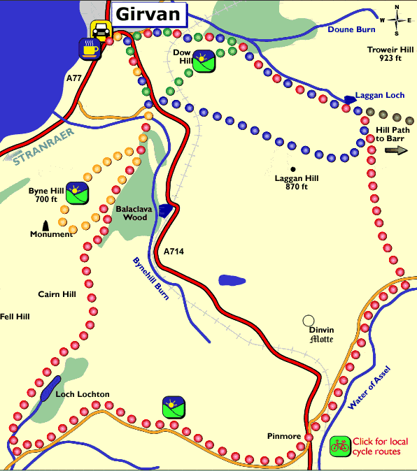
Use your browser PRINT button to print this map
Walk
via the roundabout and the A714 before turning right then left on to the
Brochneil Farm road. The Byne Hill with its rocky outcrops provides an
impressive backdrop.
Crossing the burn you pass the site of what previously was a picturesque
cottage affectionately known as "Wren's Nest".
From the shoulder of Byne Hill to the summit there is one of the best
views in the district: the Firth of Clyde with Ailsa Craig and Arran.
On a clear day the Antrim Hills of Northern Ireland can be seen on the
horizon. Inland in the distance are the Galloway Hills including the Merrick.
The excursion continues along the ridge past the cairn which was erected
by the Round Table to commemorate the Queen's Jubilee in 1977. Descending
from the ridge to the saddle, which leads eastwards, notice on the right
a monumental obelisk situated in a prominent position above Ardmillan
House. This was erected in memory of Major A.C.B. Craufuird who served
in H.M. Forces in India. He also took part in the landing at and capture
of the Cape of Good Hope in 1795.
The route emerges at Drumfairn where an unsurfaced road continues back
to Brochneil before returning to Girvan.
The
first part of the route follows the old right of way to Barr. Fine views
are afforded of the Byne Hill and the pass over which runs the high road
between the Carrick shore and the Assel and Stinchar Valleys.
A mile further on is Laggan Loch an almost perfectly circular Loch Legend
has it that the outline of a ploughman complete with yoke can he seen
on the surface of the Loch. He was reputed to have been lost in mud at
the bottom.
Crossing the drystone dyke the route continues on the track before branching
right over the whaleback summit of Laggan Hill. This is an area which
is still predominantly farmed for hill cattle and sheep.
The dominant feature is Ailsa Craig A volcanic plug thrusting over a thousand
feet from the Firth of Clyde and silhouetted against the sky. The remains
of a ruined castle can be seen on the island, which is now a bird sanctuary
and is one of the largest colonies of gannets in the British Isles.
To complete the walk back turn right at the A714 and follow the footpath
back to the town.
The
little energy that is expended in doing this local favourite brings a
rich reward. En route a good track climbs over the Ayr to Stranraer railway
line and goes past a deep ravine locally known as "Sundown Valley".
At the head of the ravine is a delightful spot where two burns meet.
The
Dow Hill (Pronounced doo) at 518ft is the site of an ancient fort and
a good viewpoint. From the top there are breathtaking views of the Byne
Hill, Ailsa Craig, the Isle of Arran, the Firth of Clyde and the town
of Girvan.
The walk is completed by descending South West to the railway line and
along the footpath adjacent to the main road. After a rest from this short
excursion the local town is well worth a visit.
Girvan is a traditional Clyde Coast tourist and fishing town. Its harbour
is a centre of attraction for visitors with sea angling trips to Ailsa
Craig. There are many interesting buildings including a townhouse tower
built in 1789 known as "Stumpy Tower". Another imposing building
is the McKechnie institute, built in Scots Baronial style in 1888. It
is now used as a local art and exhibition centre.
The
distance involved makes this a challenging walk, however it is most rewarding
and full of interest.
Follow the good track between Sundown Valley and Dow Hill. This hill and
moorland route branches off to Dalfask Farm and Pinmore. The route passes
close to Dinvin Motte reputed to be the finest prehistoric fort in Ayrshire.
It is situated on a dominating ridge just north of Pinmore. It consists
of a central mound and defended by two well defined circular ramparts
and ditches.
Just below Dinvin is the 496 metres long railway tunnel on the Girvan
Stranraer line, built in 1877. The route now lies from Pinmore down the
quiet valley of The Water of Lendal. On a rough moorland path the route
skirts the Grey Hills, a wildlife reserve managed by the Scottish Wildlife
Trust. Special features are patches of herb-rich turf situated on outcrops
of Serpentine rock, only to be found in four other localities in the British
Isles.
From the path you look down on Loch Lochton where there is a fine display
of both white and yellow water lilies. There are magnificent views over
the surrounding countryside on your return.
The
path follows the initial route of the Dow Hill and Laggan Loch path. Past
the loch the path separates and drops down to Tormitchell via the ruins
of Barbae Farm and the Water of Assel Valley.
A track leads to Dupin and then by footpath uphill over Auchensoul Hill
(1029ft), which gives fine views over Barr and the beautiful Stinchar
Valley.
The path emerges on the Old Dailly to Barr road known locally as "The
Screws" before entering Barr via the old Stinchar Bridge built in
1787.
The conservation village of Barr is well worth a visit with its attractive
rows of unspoilt 18th and 19th century vernacular buildings. The area
has a considerable covenanting history and in the old churchyard there
are two martyrs' stones. In summer the village hall provides afternoon
teas. Further walks can be explored a mile east of the village in Changue
Forest. A car park with an information board is sited detailing the network
of four circular walks.
Go prepared for muddy paths and wet weather. Stout shoes or boots and waterproofs are advisable. Not all paths follow recognised public rights of way. Please respect the environment, follow the Country Code and keep young children and dogs under control. This map is only for information purposes, we recommend taking a detailed Ordnance Survey map of the area for reference and safety.