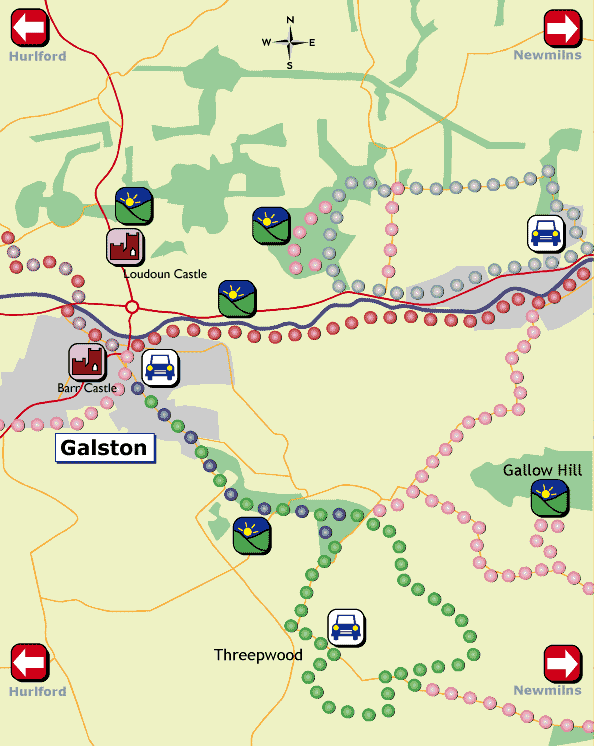
Use your browser PRINT button to print this map
(MAIN
ROUTE THROUGH THE IRVINE VALLEY)
The Irvine Valley Trail is the main route of paths linking all the Valley
towns. Tackle it as a long walk or enjoy it as a series of smaller circular
routes taking in each of the towns of Darvel, Newmilns, Galston and Hurlford.
From Darvel:
At Priestland, start on the south side of the River Irvine, and go round
the "Bankers", following a farm track from Slacks Bridge which
crosses the Gower Water and skirts around Darvel, arriving at the Ranoldcoup
Road Bridge in Darvel. Continue your walk along the south side of the
river down the Browns Road, which runs alongside the Lanfine Estate. Once
home of the Brown family, their benevolence to the Valley townspeople
is shown in the three Browns Reading Institutes in Darvel, Newmilns and
Galston. This is a popular riverside walk, where the overhanging branches
of trees provide dappled shade for the trout and salmon in the river.
Take this walk in the autumn when the river is in spate and watch the
salmon leap up the Newmilns Weir on their journey east for spawning but
watch out for bats swooping overhead if you are out and about in the gloaming!
If you're really lucky, you may catch a glimpse of the Great Spotted Woodpecker,
which has been seen along this road. Another common bird is the Dipper
bobbing on a large stone or diving into the river and is a sign of the
clean water in the river.
The Browns Road meets Brown Street in Newmilns and you can return to Darvel
via the A71 up the "Darvel Cut" as the incline towards Darvel
from Newmilns is called locally. Take a break at the Gowanbank Memorial
to Alexander Morton with its decorative panels of handloom and machine
lace weaving and savour one of the most stunning views in the Valley looking
south over the Lanfine policies of sycamore, chestnut, copper beeches
and conifers which shelter pheasants and deer.
From Newmilns:
Before you resume your walk from Brown Street in Newmilns towards Galston,
have a short stop in Newmilns to view some of the heritage buildings in
the Main Street, - The Keep in Castle Street where John Law was killed
attempting to rescue Covenanters in 1685 and now a Scheduled Ancient Monument;
the Town House built in 1739 with the town gaol on the ground floor; the
Covenanter graves of John Nisbet and Matthew Paton in Loudoun Church graveyard.
The newly renovated St Margaret's Manse often gave hospitality to Robert
Burns and the Rvd Lawrie has been given credit for preventing Burns from
emigrating to Jamaica.
Steeped in the history of the past, head back down Brown Street and spot
the 5 stained glass windows at the Royal Bank Buildings in the likenesses
of Robert Burns, Sir Walter Scott, Alan Ramsay, Robert Tannahill and James
Hogg. Pass by some of the Lace Mill buildings, which gave prosperity to
the Irvine Valley from the late 18th to mid 20th Century. Branch right
at Vesuvius and follow the tree lined riverside path past the Strath Mill,
entering a woodland strip past Barrmill and reaching Galston at the Public
Recreation Park.
From Galston:
The final section of the Irvine Valley Trail west is along the Grougar
Walk - which is more fully described elsewhere. From Barrmill Road, continue
along Titchfield Street to Gas Lane and follow the footpath to the underpass
at the Low Green Bowling Club. This leads to Loudoun Kirk and ends at
Hurlford.
An alternative route at this point, and a must for bird and wildlife watchers,
is to follow the well defined fisherman's path leading to the flood plain
of Holmes Loch between Galston and Hurlford. This is included in the Scottish
Wildlife Trust's List of Wildlife Sites and is a wild life haven and popular
area for migrating birds. Watch out for mallard duck, gulls, lapwings
(peeweets). Herons are a common sight flying over the area or standing
silently at riverside pools to catch unwary fish. Retrace your steps to
Galston.
Pass by the
Propeller, an industrial monument to Hurlford's past, and start this leisurely
riverside walk at the Hurlford Bridge. The path meanders peacefully along
the River Irvine before gently sloping upwards through two small wooded
areas towards the crossroads at Templetonburn Farm - a name associated
with the Knights Templar of olden days. Wild irises bank this woodland
stretch in early summer.
The remainder of the walk hugs the river through an historic and picturesque
rural area passing by the site of the hut where the Hermit,Tam Raeburn
lived, and Grougar Row, a traditional row of miners' cottages. When you
reach Milton, imagine the Covenanters meeting in secret in mortal fear
of the Dragoons during these troubled times.
Keen birdwatchers will enjoy viewing the wild life at Burnbank Loch. Perhaps
now you could take advantage of the excellent picnic areas located on
the banks of the Polbaith River off the Grougar Road or you may wish to
stop at Bankhead for coffee and visit the craft gallery with its picnic
area and exotic birds.
Before reaching the end of this enjoyable walk, spend a moment of quiet
reflection at Loudoun Kirk, the traditional burial place of the Loudoun
family. Founded in 1415 by Alicia in memory of her husband, Sir John Campbell
of Loudoun, this ancient and sacred place is being restored and preserved
by "The Friends of Loudoun Kirk". Belgian SAS Paratroopers who
trained at Loudoun Castle during the 2nd World War gifted a commemorative
plaque to the Church.
Follow the waymarkers to take you back into Galston or retrace your footsteps
back to Hurlford.
THE
BURN ANNE WALK at Threepwood
The Burn Anne Walk is known locally as the "Burnawn", and an
agate known as "The Burnawn stone" is found here. Start your
walk at Barr Castle and you are looking at another part of the Wallace
legend - pursued by English troops, he made his way to Galston and the
safety of Barr Castle, a stronghold also known as Lockhart's Tower, leaping
for his freedom from one of the windows to a nearby tree. He is also reputed
to have kept his men fit by playing a special handball game against the
walls of the Castle - a game played by local people until the 2nd World
War. Barr Castle is now a well-maintained museum containing many local
artifacts.
Make your way from Barr Castle for 11/2 miles to Threepwood Farm on the
Sorn Road. At Threepwood Farm, there is a car park, snack bar, picnic
area and wildlife pond to linger over before following the route uphill
for various viewpoints with impressive views over Ayrshire, Arran, Ailsa
Craig and Kintyre. The route dips down towards the Target Wood where you
can spend some time at the bird watchers hide and admire panoramic views
of The Burn Anne which are not so easily accessible on foot. The Burn
Anne Path now stretches past the East Threepwood historical site - spare
a thought for Covenanter James Smith who was shot here by "Bloody
Claverhouse and his Dragoons". Follow the peaceful woodland path
winding past Bankwood and Cessnock back towards Galston.
If you want panoramic views over Ayrshire and Arran, it would be worth
your while to take a detour uphill to the Gallow Law Cairn - the gallows
being an old Scots name for "an elevated station for a view".
Make sure you take your camera and binoculars - not only to relish the
scenery but also for the deer, fox, barn owl, raven, hawks and other woodland
birds which make this area.
Stroll
through two attractive woodlands while you are walking in the Threepwood
Farm and Burn Anne area.
Burnhouse Brae and Bank Woods straddle the Burn Anne on the south side
of Galston and link from the Burnhouse Bridge on the Sorn road through
to the Burn Anne Bridge and the minor road on the edge of Threepwood Farm.
A footbridge over the burn in Bank Wood offers alternative routes to the
road.
These ancient woodlands - in existence for over 250 years - are now dominated
by sycamore trees. Maybe you can spot the 14 other species of trees and
shrubs and attempt to guess some of the 70 species of plants nestling
within the woods.
Once the site of a lime stone quarry, the burn water was also used to
power a mill to the south of Burnhouse Bridge using an extensive lade
to route the flow of water to the mill.
"The
Bluebell planting" A starting point for this walk is the lay-by on
the A71 between Newmilns and Galston at the Hag Bridge. The walk, as its
name suggests, is a woodland walk best seen in May when bluebells form
a stunning layer of blue alongside the path.
On the west side of the Hag Burn is Loudoun Gowf Club, the only "gowf"
course in the world, with more than 400 years of golfing history - but
remnants of a Neolithic stone circle bear testimony to settlements more
than 2000 years old. Loudoun Castle, now part of the Loudoun Castle Theme
Park, is nearby and is accessed through the main entrance to the Theme
Park on the A719. The earliest part of Loudoun Castle was built in the
1400s by the Craufurds of Loudoun and the later 1800 building, known as
the Windsor of Scotland in its heyday, was almost completely destroyed
by fire in 1941. Tradition has it that the Act of Union was discussed
and drawn up under the Auld Yew Tree in 1707 - an imposing tree said to
be 700 years old. An interesting relic is the motte and bailey remains
of Arclowdun Castle, reputedly the home of William Wallace's Mother, Margaret.
The walk itself gradually inclines through woodland and burn until you
reach the gate leading to Woodhead Farm. Tread the old Lime Road and imagine
the many disputes that took place between the local townspeople and the
Loudoun family regarding access in the 1880s. Descend gently down the
"Pit Brae" to complete this attractive woodland and pastoral
walk or continue along the Lime Road catching glimpses of Newmilns below
and follow the steep winding road through the leafy glade of the Devils
Basin to return to Newmilns.
Go prepared for muddy paths and wet weather. Stout shoes or boots and waterproofs are advisable. Not all paths follow recognised public rights of way. Please respect the environment, follow the Country Code and keep young children and dogs under control. This map is only for information purposes, we recommend taking a detailed Ordnance Survey map of the area for reference and safety.