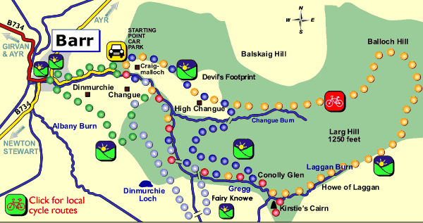
Use your browser PRINT button to print this map
Of
all the routes at Barr, this is the most strenuous due to its length.
Although designated a cycle route those wishing to walk will also find
it worthwhile.
Continuing up the Howe of Laggan there are excellent views over the Polmaddie
Hill Group, which rises to over 1800 feet. This is an area which is still
predominantly sheep country, where sheep paths and folds are evident.
The route takes you through the heart of Changue, now a commercial forest
in its many stages of development. The main species which can be seen
are Sitka Spruce, Norway Spruce and Larch with some broadleaf trees including
oak, ash and birch.
Looking northeast you can see that well-known Galloway mountain pass called
"Nick of the Balloch". In olden times this was famous as a smuggling route.
Men with pack horses would follow the perilous path and at the summit
drink from the "brandy well", a spring which still flows with clear crystal
water.
The word "Changue" of Gaelic origin means the large rounded hill-shoulder
of the nigh impenetrable inner row of storm-swept mountains. A lengthy
meaning perhaps but one which accurately describes this area, especially
during winter. This is a notable excursion taking in the full aspect of
the forest with its many magnificent views.
The
first part of the walk follows the Water of Gregg for two kilometres before
branching off and climbing steadily through the woods along an attractive
grass path.
Near the highest point beautiful views open up across the Stinchar Valley
to the hills beyond. The walk leads steeply down a gully and across Changue
Burn.
In spring and summer numerous wild flowers such as primroses and bluebells
can be seen in this area. The edge of the burn is planted with small-leafed
lime.
Legend has it that near High Changue, there is the site of a famous battle
between the Laird of Changue and the Devil. The story goes that Changue
was getting short of money and he decided to make a bargain with the Devil.
He would sell his soul in return for great wealth. The Laird's fortunes
changed and he prospered for many years. When the time came to deliver
his soul the Laird reneged on his bargain and refused to go. The Devil
proceeded to lay hold of him, but Changue placing his Bible on the turf
and drawing a circle with his sword around him, sturdily and, as it turned
out, successfully defied his opponent. The story must be true because
to this day on the hill above High Changue you can still see the Devil's
footprints, the circle drawn by the sword and the mark of the Bible clearly
visible on the grass.
As you descend westwards, the walk back is a delight with glorious views
across the valley to forest and hills beyond.
For those who appreciate a combination of forest and open hill, this walk
will suit admirably. Following the track through the forest you suddenly
clear the trees at the top of the hill, from where you can look down on
the picturesque village of Barr and across the Stinchar Valley.
If you are lucky you may see some of the wildlife including deer, foxes,
hares, kestrels and buzzards. The route now descends along the old road
which runs from the Water of Minnoch to Barr as described in Armstrong's
1773 map of Ayrshire.
The village of Barr is known by local people as "The Barr" which is thought
to mean the confluence of the waters. The trail passes close to Dinmurchie
Farm which was the birth place of James Dalrymple (1619- 95) who became
the first Viscount of Stair and was the author of the "Institutes of the
Law of Scotland". The village is worth exploring from the historical viewpoint.
The area has a considerable Covenanting history. In the old churchyard
there are two Martyrs' stones, one of which is to Edward McKeen who was
arrested by soldiers at the farm of Dalwyne following suspicion that a
prayer meeting was taking place. He was dragged out and after some questioning
the officer in charge shot him twice through the head. One of the soldiers
of the party thought he saw McKeen move and shot him a third time. This
all happened in 1685 when such events were commonplace in the "killing
times", however Barr is now noted for its peace and tranquility.
To stroll back along the narrow road which follows the Water of Gregg
with its attractive wooded banks makes a fitting end to a memorable walk.
No climbing is required in this, the easiest of the Barr routes. The trail follows the delightful Water of Gregg up the valley to the Howe of Laggan, passing through mature woodland as far as Kirstie's Cairn. Christopher McTaggart (Kirstie to his friends and family) a nineteen year old shepherd lad set out on January 11th 1913 in a raging blizzard to care for his sheep. Later that day he was found dying by his twin brother David and two friends. Their efforts to restore heat to his frozen body were in vain. He died fifteen minutes later. With such weather they were unable to carry his body back. Kirstie's faithful dog "Wag" refused to leave his master. The following day between twenty and thirty men set out for the Howe of Laggan to bring back the body of their friend. At Kirstie's funeral the Reverend John Angus charged the young men of the village to raise a memorial to the young shepherd and this they did by building a cairn a few yards from the spot where he died. Returning walkers should look out for roe deer and amongst our feathered friends long-tailed tits, jays, siskins and bullfinches.
Go prepared for muddy paths and wet weather. Stout shoes or boots and waterproofs are advisable. Not all paths follow recognised public rights of way. Please respect the environment, follow the Country Code and keep young children and dogs under control. This map is only for information purposes, we recommend taking a detailed Ordnance Survey map of the area for reference and safety.
Most of the routes could be described as moderate, however there are sections on the Devil's and Dinmurchie Trails which involve some steep climbing.